One of the things this blog allows me to do is think about what I'm trying to accomplish. By putting it all down in electrons and pixels I can get a better idea of how I want things. It's like bouncing ideas off friends. You get to talk out the pros and cons and this refining process produces better ideas and uncovers bad ones.
I can also sort through and preserve ideas and information I've accumulated in a place where I can readily access them. My library and computer are full of hundreds, if not thousands of bits of information, drawings , articles, photos and other stuff pertaining to railroads and things related to railroads. I cannot keep track of even a fraction of all of that.
So...Anyway...As I mentioned some time ago, information shared by Josh Surkosky on his Allegheny Division layout has affected the design of the Allegheny Eastern. His questions prompted more research and led me to revise and finally abandon the Blair Furnace scenario. I looked deeper into the coke operation of the Glen White Coal & Lumber Company.
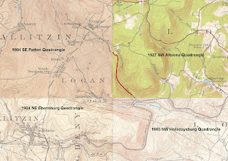
Once again the results of your research depend on your sources. The Pennsylvania Railroad may have had a siding or sidings at Horseshoe Curve. Then again, they may have been separate properties. The topo map I have is a composite of maps from the early decades of the 20th century. I labeled the various parts so you can see the years each was created. It shows two "sidings". One runs up Kittanning Run (east of The Curve), while the other runs up Glenwhite Run (west of The Curve). Forgive the red line. I was trying to fill in the implied path of the Kittanning Run Railroad.
The PRR siding shown in the topo map ran parallel to the main tracks west of the Curve, but was vertically separated by a stone wall. It turns left when it gets to the Run and continues west until it reaches a set of coke ovens one or two miles up the ravine. At that point it follows along side the lower side of the ovens. The tracks of the Glen White Co. do the same thing, but at the upper side of the same ovens.
Other information I have found, like Sam Berliner's website, state that there were two sidings into the ravine of Glenwhite Run, one on each side. Sam believes there was even a wye on the north side, right at Horseshoe Curve. Charles Roberts also mentions this wye. That feature also appears in some early postcard images.
According to the Pennsylvania Department of Transportation, in 1915 both the Glen White and the Kittanning Run railroads were longer. The Glen White was a single track directly connected to the PRR. The Kittanning Run also connected to the PRR, but at the Kittanning Point station and freight house. The Kittanning Run also had a spur, not shown on this map, that served the overhead coal and water facility that was located east of the station. That spur can be seen in the map above and on many photos taken of the facilities at Kittanning Point...
 |
| PennDOT 1915 Blair County Map: Glen White Coal & Lumber |
 |
| Sligo & Eastern #7 later Glen White #7 |
 |
| Sligo & Eastern #7 |
The photo was, believe it or not, on a website focused on the Frisco Railroad! Like I said before...Read everything.
According to some sources, I think Sam Berliner for one, the siding/branch along Kittanning Run on the east side of Kittanning Point was also part of the Glen White "empire" (if you could call it that). I think there are also vague references suggesting this in a Bureau of Mines Report. Either way, the 1915 PennDOT maps of Blair and Cambria counties shows a Kittanning Run Railroad which connected to the PRR on the east side of The Curve. Notice the switchback, but no indication of the spur to the coaling facility...
 |
| 1915 Blair/Cambria Composite Map: Kittanning Run Railroad |
 |
| Kittanning Point Coaling Facility |
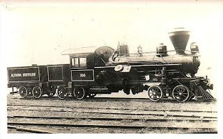
Another idea that the redesign affected is the Altoona Northern. This short line railroad changed names at least six times during its brief existence, most times because of reorganization after a bankruptcy. This line started out in 1891 as the Altoona and Wopsononock Railroad. It provided a 3 foot guage connection between Juniata and the resort town of Wopsononock. It was extended another 5 miles to mines near Dougherty in 1892. Both resort and the mine tipple burned down in a forest fire in 1903. This resulted in still another receivership in 1910. Somewhere around 1913 it became part of an attempt to construct an electric interurban line. Yet another failure. In 1916 it was taken over by investors who widened the track guage to the standard 4'-8 1/2". Three Pennsy F class 2-6-0 steam locomotives were purchased but were not suitable to the grades and curves. They were replaced by Heislers soon after...
 |
| Altoona Northern Heisler #106 |
 |
| The revised "Blair Furnace" |
 |
| The original "Blair Furnace" |
While I still want to provide connections to the Pennsy at Horseshoe Curve and Bennington, I've reduced the entire thing by quite a bit. All the curves are much tighter, as befits railroads with small geared engines. This also means the grades are much steeper, another reason to use geared locomotives. I'm still using the same "empties in" "loads out" scheme. It's similar to the John Armstrong idea but without the actual industries. Empties are dropped off at the Glen White interchange at Horseshoe. They are dragged away by a Shay and dropped at the "yard", the passing siding behind the backdrop. The Altoona Northern switcher picks them out of the yard and delivers them to its own interchange at Juniata as empties to be picked up. Same with loads. They come in on one interchange as deliveries and may go out the siding at SF as product. Any kind of freight can be handled this way, coming and going at any of the three connections. Just to make things interesting I have also added some actual industrial sidings along the way. At least one of of them is coal, lumber and building supply firm modeled after one from a Sanborn map of Altoona...
 |
| Canan Knox Supply Co. |
I don't know if this idea will work at all. I'll have to mock it up in the allocated space before I do any construction. For the present I'm concentrating on getting the mainline up and running.
Regards,
Frank Musick
Chief Cook and Bottle Washer
 |
| Allegheny Eastern Railroad |


No comments:
Post a Comment