Thursday, May 30, 2013

The Other Railroads on the Allegheny Eastern


One of the things this blog allows me to do is think about what I'm trying to accomplish. By putting it all down in electrons and pixels I can get a better idea of how I want things. It's like bouncing ideas off friends. You get to talk out the pros and cons and this refining process produces better ideas and uncovers bad ones.

I can also sort through and preserve ideas and information I've accumulated in a place where I can readily access them. My library and computer are full of hundreds, if not thousands of bits of information, drawings , articles, photos and other stuff pertaining to railroads and things related to railroads. I cannot keep track of even a fraction of all of that.

So...Anyway...As I mentioned some time ago, information shared by Josh Surkosky on his Allegheny Division layout has affected the design of the Allegheny Eastern. His questions prompted more research and led me to revise and finally abandon the Blair Furnace scenario. I looked deeper into the coke operation of the Glen White Coal & Lumber Company.

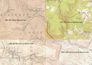
Once again the results of your research depend on your sources. The Pennsylvania Railroad may have had a siding or sidings at Horseshoe Curve. Then again, they may have been separate properties. The topo map I have is a composite of maps from the early decades of the 20th century. I labeled the various parts so you can see the years each was created. It shows two "sidings". One runs up Kittanning Run (east of The Curve), while the other runs up Glenwhite Run (west of The Curve). Forgive the red line. I was trying to fill in the implied path of the Kittanning Run Railroad.


The PRR siding shown in the topo map ran parallel to the main tracks west of the Curve, but was vertically separated by a stone wall. It turns left when it gets to the Run and continues west until it reaches a set of coke ovens one or two miles up the ravine. At that point it follows along side the lower side of the ovens. The tracks of the Glen White Co. do the same thing, but at the upper side of the same ovens.

Other information I have found, like Sam Berliner's website, state that there were two sidings into the ravine of Glenwhite Run, one on each side. Sam believes there was even a wye on the north side, right at Horseshoe Curve. Charles Roberts also mentions this wye. That feature also appears in some early postcard images.

According to the Pennsylvania Department of Transportation, in 1915 both the Glen White and the Kittanning Run railroads were longer. The Glen White was a single track directly connected to the PRR. The Kittanning Run also connected to the PRR, but at the Kittanning Point station and freight house. The Kittanning Run also had a spur, not shown on this map, that served the overhead coal and water facility that was located east of the station. That spur can be seen in the map above and on many photos taken of the facilities at Kittanning Point...
PennDOT 1915 Blair County Map: Glen White Coal & Lumber


Neither railroad went far. The coal mines were only a few more miles up each ravine. Depending on your source, they did or didn't serve the towns shown on the maps, Glenwhite to the west or Coupon to the east.  Some of the sources claim the Glen White railroad was narrow guage. In that case it would not have been able to interchange with the Pennsy. Yet there is strong evidence that it was a standard guage railroad at some time. Roberts makes reference to second hand PRR motive power for one. I found while double checking some info on the company's only Shay that it was built for standard guage. According to ShayLocomotives.com shop number 2883 was built in 1916 for the Sligo Furnace Company's Sligo & Eastern Railroad. A 70 ton 3 cylinder 3 truck class C, the locomotive went up for sale in 1930. It was purchased by Glen White Coal & Lumber in 1931...
Sligo & Eastern #7 later Glen White  #7
The website doesn't have a photo of the old girl but I was able to find this image by searching under Sligo & Eastern Railroad...
Sligo & Eastern #7

The photo was, believe it or not, on a website focused on the Frisco Railroad! Like I said before...Read everything.

According to some sources, I think Sam Berliner for one, the siding/branch along Kittanning Run on the east side of Kittanning Point was also part of the Glen White "empire" (if you could call it that). I think there are also vague references suggesting this in a Bureau of Mines Report. Either way, the 1915 PennDOT maps of Blair and Cambria counties shows a Kittanning Run Railroad which connected to the PRR on the east side of The Curve. Notice the switchback, but no indication of the spur to the coaling facility...
1915 Blair/Cambria Composite Map: Kittanning Run Railroad

Kittanning Point Coaling Facility

Another idea that the redesign affected is the Altoona Northern. This short line railroad changed names at least six times during its brief existence, most times because of reorganization after a bankruptcy. This line started out in 1891 as the Altoona and Wopsononock Railroad. It provided a 3 foot guage connection between Juniata and the resort town of Wopsononock. It was extended another 5 miles to mines near Dougherty in 1892. Both resort and the mine tipple burned down in a forest fire in 1903. This resulted in still another receivership in 1910. Somewhere around 1913 it became part of an attempt to construct an electric interurban line. Yet another failure. In 1916 it was taken over by investors who widened the track guage to the standard 4'-8 1/2". Three Pennsy F class 2-6-0 steam locomotives were purchased but were not suitable to the grades and curves. They were replaced by Heislers soon after...
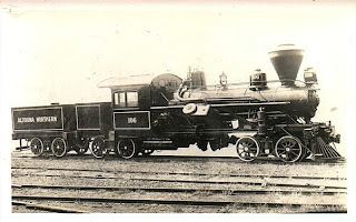
Altoona Northern Heisler #106
It would be great to have two short lines that interchange with the Pennsy (both using geared steam locomotives). The inclusion of the flyover at Homer takes up some of the space formerly set aside for this part of the project. I had to come up with a smaller version of the Blair Furnace idea...
The revised "Blair Furnace"
The original "Blair Furnace"


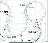
While I still want to provide connections to the Pennsy at Horseshoe Curve and Bennington, I've reduced the   entire thing by quite a bit. All the curves are much tighter, as befits railroads with small geared engines. This also means the grades are much steeper, another reason to use geared locomotives. I'm still using the same "empties in" "loads out" scheme. It's similar to the John Armstrong idea but without the actual industries. Empties are dropped off at the Glen White interchange at Horseshoe. They are dragged away by a Shay and dropped at the "yard", the passing siding behind the backdrop. The Altoona Northern switcher picks them out of the yard and delivers them to its own interchange at Juniata as empties to be picked up. Same with loads. They come in on one interchange as deliveries and may go out the siding at SF as product. Any kind of freight can be handled this way, coming and going at any of the three connections. Just to make things interesting I have also added some actual industrial sidings along the way. At least one of of them is coal, lumber and building supply firm modeled after one from a Sanborn map of Altoona...
Canan Knox Supply Co.
.
I don't know if this idea will work at all. I'll have to mock it up in the allocated space before I do any construction. For the present I'm concentrating on getting the mainline up and running.

Regards,
Frank Musick
Chief Cook and Bottle Washer
Allegheny Eastern Railroad


Wednesday, May 29, 2013

Bending Space and Time

The mainline roadbed is in place and elevated. There is a steady 1.5% (or there abouts) westbound climb up the east slope from SLOPE to Gallitzin. Eastbound trains will drift downhill over a short 2% grade called The Slide before they reach the gentler 1.5% descent from McGinleys Curve down to SLOPE...
Bennington Towards Horseshoe


Trains heading west out of Gallitzin descend the "west slope" at just a hair under 2%, while trains coming east have an easier 1.5% climb. The west slope is represented by a three and one half level four track helix. Since there is not enough room to model the west slope to Johnstown, the helix returns the mainline to the eastern end of the layout. That end is represented by the bridges and tunnels at Spruce Creek...
Juniata River, Spruce Creek


The balance of the right of way is level, except for Track 4 at Homer, which passes over Tracks 2 and 3 on a short flyover. In the real world this flyover was across the yard from the East Altoona roundhouse and was actually the approach to the "hump" for the westbound classification yard. On the Allegheny Eastern there was no practical way to model the hump yard, but I wanted the appearance of HOMER on the layout...
East Altoona Towards HOMER

Pictures of other areas of the layout ready for ballast strip and track...
Horseshoe
Bennington


Horseshoe Towards Slope
UN Towards Tunnels


Sometimes you trip over things you would never find through more normal channels. They're not necessarily things you want to know but you learn them in spite of yourself. Case in point, the Pennsylvania Railroad and applied physics. Please excuse my rather verbose and self indulgent "treatise" on the subject.

On the revised version of the track plan dated May 27th 2013 I created a new set of "mile markers" that includes the entire layout, not just the east slope. I couldn't think of another name for them, but they are not spaced a scale mile apart. Instead I put one every every 12". I use them as reference for all kinds of things, mainline and block length, speed estimates, signal locations and several other uses. All of them are numbered on the plan although in the drawing below the numerals are not visible. You can, however, make out the circles on the tracks that indicate a "mile marker". . I did not bother with mile markers in the helix. The track length in the spiral is approximately 34.5 feet, just over a scale mile. I may add some kind of markings to the helix itself, for reference, but not to the plan.
Allegheny Eastern May 27th, 2013

You can see that the visible mainline splits, merges, crosses over itself and twists in all kinds of confusion. This isn't an attempt to get too much railroad in a small space (although it sure looks it). I tried to replicate in miniature some of the things that caught my attention about this stretch of the PRR. This resulted in complications I had never even imagined. It also made me realize some of the confusion a multi-track mainline can cause for a real railroad. Hopefully I can illustrate some of these challenges as faced by the Allegheny Eastern

MP001 is at the beginning of the Spruce Creek area, 0" elevation as far as the layout is concerned. Tracks 1 and 2 (right) are already split from Tracks 3 and 4 (left) as they emerge from the tunnel portals.  MP001 is the same on all tracks. All four tracks share the same mile markers as they approach Forge Curve at the lower right corner. Round about MP004 that starts to change. Tracks 3 and 4 start to "pass" the other two, chiefly because of the differing radii of the curves...
Mile Markers at Spruce Creek

Passing through Forge the inner tracks gain about 6" and stay that way until the flyover at HOMER. This is where Track 4 passes over Tracks 2 and 3. Meanwhile Track 1 continues uninterrupted on its way into East Altoona. This small space is where the confusion really begins. You can see there are THREE MP010's! Tracks 1, 2 and 3   line up, but Track 4 pulls ahead of Track 3 by another few inches. There is also some issue with track identification. Technically, the track arrangement (starting from the South) is now 1, 4, 2, 3. Tracks 1 and 4 come together as they enter East Altoona, albeit at different mile posts. Tracks 2 and 3 start to bypass Juniata on their way to Altoona...
Mile Markers at HOMER

By the time they pass East Altoona, Tracks 2 and 3 are beginning to fall behind as the four tracks curve toward Juniata. By the time Tracks 1 and 4 reach the yard Track 1 has gained nearly a foot.on 2 and 3....
Mile Markers at East Altoona

This situation gets more confused as the mainline reaches Altoona station. The passenger mains (Tracks 2 and 3) are well over a foot behind Track 4 and almost three feet to the rear of Track 1. Rather than keep going with three different sets of mile markers, at MP033 I stopped with the separate markers for tracks 2 and 3  By MP035 all four tracks have a consistent mile marker. I also returned to the "normal" track arrangement of 1, 2, 3 and 4. The crossovers allow trains to move to the "proper" track for their ascent of The Hill. I did leave the Track 1 markers as a reference. This is the longest track and is used to measure the overall length of the mainline...
Mile Markers at Altoona

This goofy offset continues through the entire climb up the east slope until the mainline enters Bennington. At this point the tracks split again. 1 and 2 (eastbound) stay together and pass through New Portage tunnel. Tracks 3 and 4 (westbound) split from each other and run parallel into the twin tunnels, Gallitzin and Allegheny. As the westbound tracks sweep around Gallitzin they gain "mileage" on the eastbound. By the time the main merges west  of Gallitzin the westbound main has traveled five feet more than the other...
Mile Markers at Gallitzin


So what has this to do with anything? Believe it or not, it's not just a "difficulty" with the trackplan of my model railroad. It happens on real multi-track railroads. Consider the very railroad the All East represents, the Pennsylvania. Take a look at the track chart at SLOPE from 1945...


Now aside from the juxtaposition of track numbers (other railroads number in reverse starting from north) there are curious notations at the top. See the numbers between the mileposts. They are there to indicate the distance between mile markers. The key word here is "mile". In school I was taught that a "mile" is 5,280 feet. So it has always been, at least since they standardized measurements. It is not 5,266, nor is it 5,313 or any of the other numbers on this track chart. In fact the number 5,280 turns up but three times between MP214 and MP250. I haven't looked at charts for any other railroads, so I don't know if this was a common practice. Because of the eccentricity of the Pennsy, I wouldn't be surprised if the management decided to interpret the term "mile" to suit their own purposes. Near as I can tell it can be anywhere between 4,646 to 5,311 feet.

I have no idea what lies behind this. The most obvious to me is that no matter how you slice it all track lengths of a four track mainline cannot be equal. Maybe the PRR figured it didn't really matter and picked an average distance. It could also be a result of one hundred odd years of changes, improvements, repairs and God knows what other influences. I'm sure there was a definite reason to shrink or stretch a mile. It does make one wonder though. Regardless of Einstein or Hawking, the Pennsylvania Railroad apparently had no problems bending the time-space continuum to their own needs. In model railroading we have gotten used to fast time clocks and "smiles" to make our mainlines longer and allow us timetable operation. It's been like that for decades, I just didn't know there was a prototype for it.

The area being modeled on the All East extends from MP214 at Spruce Creek to MP250 at Gallitzin. According to the mile posts on the charts that distance is about 36 miles. According to the numbers between the mileposts, the actual distance is about 35.75 miles. Mind you there are some gaps in the notations. No distance is noted between MP036 and MP037. This is where the Middle Division meets the Pittsburgh Division. I assumed this distance was an actual standardized mile. The other gap falls between MP239 and MP240. All the chart shows are the numbers 67. I guessed at 5,267. To me, however, the missing 0.25 miles doesn't compare with the disparity of the indicated distance in feet. Of the 36 numbers noted, about 30 of them are not equal to any of the others and almost none of them measures an actual mile. The miracle is that they managed to make all of these odd distances add up to 36 miles, give or take. I checked several charts I have for the Pittsburgh Division from 1941, 1945 and 1958 as well as Sam Beliner's 1972 charts at his PRR site. Same numbers no matter what decade you reference after 1941.

I can only conclude that there really is a prototype for every situation, no matter what dimension, time or position in space you are viewing it from.

Regards,
Frank Musick
Chief Cook and Bottle Washer
Allegheny Eastern Railroad

Sunday, May 26, 2013

Bondo?

The spline is holding up well. On more than a few occasions I have found myself leaning on it. One particular spot at HOMER should be destroyed by now. I've been reaching over the westbound freight main to work on the roadbed around.SF. Nothing has happened so far, despite the fact that there is a joint there...
Westbound Freight Main

Apparently it can withstand a lot of stress. I'm thinking of leaving the hardshell off except for spline that is close to an aisle. The railhead is more than 50" above the floor (at Gallitzin it's about 63"). so I don't think even the most adventuresome of my grand kids would be climbing up there. As for other creatures that might give it a try we got rid of that cat years ago...
"Chessie"

Because the roadbed is so easy to modify, I find myself reworking sections until I think they're perfect. If a curve doesn't look right I have no reservations about redoing things until it flows like it should. I've also found that the sanding "bar" I purchased at the hobby shop works great. I throw some 80 grit on and level things out. It cuts through the foam easily enough, but the glue between strips leaves little ridges. Seems as though tacky glue is harder than foam...
Sanded Roadbed


For a while now I have been using Woodland Scenics foam ballast strip. It works and is easy to install using glue. It does, however, "give" if pressed on. It gives enough that I push the track down out of the way to reclaim track nails. I had no real issues with it but I switched to cork this time around. WS ballast strip is almost $10 for 24 feet. I can buy a roll of foam for $15 and cut it into 1" strips. All told, that's about 192 feet of ballast strip. The cork is just flat out cheaper. There is over 400 feet of mainline on the All East. That's over $160 worth of WS foam strip. It's only $30 using rolls of cork. I cut it into 1" strips using a 1" wide length of aluminum bar stock from Lowes (advertisers take note) and a utility blade. ThingX is set for 2" cuts and is better left to cutting styrofoam...
Cutting Ballast Strip

I've been experimenting with different fillers for the low spots. Body filler seems to work without attacking the foam, but it's a rather expensive way to cover 130 square feet of roadbed. My wife suggested I try caulk. Definitely cheaper but I'll have to try it out. I did use "Bondo" on a short stretch of roadbed at SLOPE. I then tried laying some cork on the spline.. It looks good even in photos, which are a lot sharper than my eyes these days. I tried it over a filled section...
Sanded and Filled Spline at SLOPE
Ballast Strip Over Sanded/Filled Spline


I then laid it over an unprepared area for comparison. This is the freight spline leading to Juniata yards...
Unprepared Spline
Ballast Strip Over Unprepared Spline


While it doesn't seem to be a problem, I don't think it's a good idea to just throw the cork down without prepping the roadbed.

If you've been paying attention you may have noticed there are sections of Code 55 track going down at SLOPE. This is the first trackage on the open area of the Allegheny Eastern in several months. It's far from done, but trackwork has started.

Regards,
Frank Musick
Chief Cook and Bottle Washer
Allegheny Eastern Railroad


Friday, May 24, 2013

Embarrassment

When I titled that last entry "Major Miscalculation" I had no idea how appropriate that would prove to be.

I have to apologize for a HUGE mistake I made in my last posting. Fortunately Gary Hinshaw was kind enough to tell me I screwed it up. When I calculated the grade on the westbound tracks through the helix I used 18.25" instead of 36.5" like I should have.

The total track length of about 401". An 8" rise in 401" is a pinch under 2%.

Gary also provided a formula even I could understand...(Elevation/Turns*(pi*Diameter))*100 = Grade.

So armed with this new knowledge I don't feel as concerned about the engineers on my westbound trains. They will be descending the "west slope" on a 1.99% grade. That isn't nearly as bad as The Slide going east.

We learn by our mistakes.

Thanks again Gary.

Frank Musick
Chief Cook, Bottle Washer and Lousy Mathematician
Allegheny Eastern Railroad

Major Miscalculation


I was reading back through a thread on Railwire this morning. It was a Layout Engineering Report on Cody's PRR Northeastern Division. I came upon this posting and stopped...
"No problem with super elevation pulling 75 Atlas 55 ton hoppers up the helix with 3 atlas TrainMaster  but had to add a GP7  pushing to get it up. Would recommend when planning to use the outer loop for going up. Locos have a easier time on the outer loop going up."

It caught my attention because I understood the problem. The inner tracks travel a shorter distance than the outer tracks, so the grade must be steeper. It doesn't look it. All the tracks rise at the same angle...

"West Slope" Helix

How can that be? The inner tracks in a helix have a different overall length than the outer tracks. The distance traveled to reach a certain elevation is part of the grade equation.

Made me think about it. I was wondering about the inner tracks on my helix. I guessed the grade might be tougher as the overall length is shorter, but I never really looked into it. Up until now I've been using the outer 22" radius to figure grade etc...The total track length over three and a half levels is just a hair over 40'. A rise of 8" in 484" is about 1.2% (I think).

The innermost track is 18.25 " radius. Total track length is 16.75 feet. That's 8" in 201"...That's about 4%.  WOW! What a HUGE difference between the outer and inner tracks. How can my little locomotives climb a 4% grade. That would make the grade well over twice as tough as the real west slope! Am I going to need a fleet of helpers stationed at the base of the helix?


I almost threw in the towel at that point. I would prefer 22" be the minimum on the helix but space limitations demand the helix fit in 4' x 4' so there is no way. I can't make the westbound grade any easier...


Then BANG! it hit me. That's just it. It's the WESTBOUND grade, stupid. The trains on the inner tracks are going DOWNHILL. Although it's more extreme, it is a similar case to the eastbound trains descending The Slide. You need good brakes, not tractive effort. I didn't plan it that way, I just lucked out. Mr. Thomson built the real railroad that way :-)


Aside from reading Railwire threads, I've been going around "tweaking" the roadbed during breaks from anchoring the vertical supports. It may seem a tad late but I laid down the 16' foot long plan of Juniata on the pink slab. Needed to find out if the mainlines actually went where they were supposed to. They did not. At the west end of Juniata I was pretty close...
Close, But No Cigar.

Once again the flexibility of the spline came to my rescue. I undid the screws and simply realigned the roadbed with the plan...
Realigned Passenger Roadbed

I did the same thing for the freight mains through Juniata yards. The roadbed is not quite complete, but I grafted in a section....
Realigned Mains

East Altoona was a whole 'nother story. Missed by a mile...
East Altoona Misalignment

I used the same solution. But I may have to rework the curve on the freight mains. The alignment is just outside the splines "limit of flexibility". A new section of spline will need to be built...
East Altoona Mains Realligned, Sorta'

Now about this time, if not already, some guys are out there shaking their heads. "Better planning would have solved this before it happened". Yea, it might. But I'm not John Armstrong, if you take my meaning. I'm just some guy who likes trains.

Regards
Frank Musick
Chief Cook and Bottle Washer
Allegheny Eastern Railroad


Thursday, May 23, 2013

A Minor Revision


Using styrofoam for roadbed allows "revisions" to be made on the fly, so to speak, while the layout is still under construction. Sooo...If you find you screwed up or new information becomes available you can change it without redesigning or rebuilding the whole kit and kaboodle. Case in point, SF and the approaches to the east portals of the twin tunnels. When I first laid this area out, I didn't have any reference photos of the portals themselves, just a picture or two taken from Tunnel Hill looking east. Upon reading Triumph I I found a plethora of views of the east portals taken over the decades.

I realized I had guessed wrong at how this area might look. While the westbound mains split, they do not get too far apart.. This was a mistake I made in both the plan and the spline construction...
Plan at SF
Spline at SF


In fact after the westbound tracks split they stay at the same distance apart at SF, through the tunnels and out the west end....
East Portals 1934

East Portals 1940's


I want the same appearance on the layout. Obviously, I have to change the splines to accomplish this. I looked the area over and decided this best way to do this would be to "stretch" Track 3 and expand the radius to nestle inside Track 4 (Pennsy tracks are numbered backwards from the rest of the world). Since the splines are made of styrofoam this should be an easy modification.

First I have to decide where and how I'm going to extend the spline. I chose a spot to the "west" where the tracks run parallel and made a slice with a utility blade...
Cutting Out Existing Spline

Once I made a vertical cut I needed to use "Delaminator" to separate the strips. I guess I should note here that "Delaminator" has a dull blade from years of neglect. This makes it ideal for its purpose. A sharp blade would slice through the foam, not necessarily at the seam where you want it. As it is the knife splits the bond between sections and not much else...
"Delaminating" Spline

I then separated the spline down the middle ending up with a set of staggered joints. The idea here is to move the sections apart and put a new length of spline to fill the gap...`
Finished Separation

This all sounds really good, and is very easy to do. Unfortunately I ran into two things I needed to correct. First was the fact that I should have cut out a larger section. When I added in the short "extension" shown here I found I had to add outer reinforcements to make a strong joint. A similar situation existed on Track 4 in the same area. I didn't like either so I redid them both. This was probably a good thing...
Delaminating Patch Job

As I was working on this the second thing showed up. Remember when I said make sure you remove the plastic coating from the foam. Well...I SHOULD HAVE REMEMBERED TO REMOVE THE PLASTIC FROM THE FOAM...
Plastic Discovered on Foam Strip

I guessed correctly that the plastic would impair the glues effectiveness. Sometimes I hate being right. While I had to use some elbow grease while using Delaminitor where the glue worked, I was able to to take a huge section of spline apart by just running my finger between the strips. How huge a section?
Undone Spline

I was able to pull strips apart through Bennington, McGinleys Curve and a quarter way into Horseshoe Curve. Thank God I have extra lengths of spline on hand. It took about an hour (maybe less) but I was able to put it all back together...
Rebuilt Spline

The end result was that Tracks 3 and 4 now run parallel to each other from SF through the tunnels and into Gallitzin. Once I get the clamps off at McGinleys Tracks 3 and 4 will come into Bennington together and start to draw apart at BF...
Revised SF Area

All this interrupted the process of fastening the roadbed to the supports. Once the glue sets that task will continue. There are a couple of other areas of roadbed to tweak but ballast strip and track may start appearing any day now.

Regards,
Frank Musick
Chief Cook and Bottle Washer
Allegheny Eastern Railroad