A short while ago, a fellow named Josh Surkosky started a thread on his
Allegheny Division at
Railwire on his hollow core door (aka HCD) layout. It's a small model pike with a big theme. Josh is modeling the Pennsylvania Railroad. You don't need an entire basement (or your whole garage) to capture the flavor of the PRR. Several other N scale modelers have managed to create the impression of the big road in a small space. Links to these and some larger Pennsy layouts can be found at
Keystone Crossings one of many online repositories for all things PRR.
Anyway, the point of this epistle is how that discussion thread affects the Allegheny Eastern. Josh asked for input on his initial layout idea. He was attempting to create a track plan based on the PRR trackage at Gallitzin Pennsylvania...
 |
| PRR Track Arrangement, Gallitzin Pennsylvania |
Replies to his thread brought suggestions on changes he should make to better represent the area in question and the Pennsy itself. While the discussion was very helpful for Josh, it also provided a solution for me. Model railroaders as a species tend to pick up ideas where ever they find them and I'm no different. Dave Smith posted his idea of a plan that suggested ways to model PRR iconic scenes in the 26 square feet Josh has available. His depiction of the wye at Cresson was simple and didn't require a lot of space, just one corner of the HCD. This started me thinking...
When I added the additional square footage to the All East, I decided to sacrifice the large area that was Gallitzin. This area included some trackage for an operating New Portage branch...
 |
| Gallitzin February 4th 2012 |
I extended the benchwork and at the same time created two penninsulas separated by a two foot aisle...
 |
| Same Area Today |
Aside from compressing Gallitzin (now Tunnel Hill) into half the space, I also abandoned the idea of modeling a part of the New Portage branch and the junction controlled by SF (Sugar Furnace) tower.
Dave's drawing made me realize I could still model the Sugar Furnace scene. If I took his idea for Cresson and adapted it to the All East, I would be able to "suggest" the junction. Unlike the previous version which actually had an operating scheme and small staging yard, the new version would be cosmetic.
The junction at Sugar Furnace is a bit different than the trackage at Cresson. Rather than a straight forward solution like the wye, the Pennsy engineering department had to create a flyover. This allowed the New Portage tracks to pass under the eastbound mains and connect to the westbound. At the same time they had to connect the eastbound tracks to the branch.
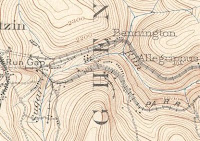 |
| Topo Map of Bennington PA |
 |
| Topo Map of Cresson PA |
You'll probably notice something odd about traffic flow on and off the branch. It is odd. Be that as it may, since all I am creating is the illusion of the junction at SF, traffic direction doesn't matter.
So back to Dave's interpretation of Cresson...
 |
| Dave Smith's Representation of Cresson, Upper Left Corner. |
You can readily see how Dave has suggested the Cresson wye and branch without actually creating either. On the Allegheny Eastern Sugar Furnace can be represented the same way. There is, however, a problem in modeling Sugar Furnace. I have found very few (if any) photographs taken at SF tower and certainly no aerial views so I've had trouble visualizing the site.
Then one day I was looking through a website that features 3D digital train simulators. I had been involved in this kind of modeling and I still keep tabs on what is going on. I came across images of a 3D "route" created by a guy who is apparently stationed at Vostoc Base in Antartica. His virtual model railroad represents the
Pennsylvania Middle Division and fits on a computer (there can't be a whole lot of room where he's at). If you get a chance make time to read the entire thread. Look for entries under the name cascaderailroad. The route contains scenes long gone from the Pennsy. ALL of the Middle Division is there, including parts that were abandoned before World War II...
 |
| Kittanning Point on the PRR Middle Division for Trainz |
Among a lot of other awe inspiring things I found screen shots of Sugar Furnace. Since the route was under construction the scenery hadn't been completed yet. The New Portage junction was clearly visible. What's more, it was pictured from both directions.
 |
| Sugar Furnace Looking West |
 |
| Sugar Furnace Looking East |
How accurate are these images? Here's a screen shot of the modeled terrain, which is constructed using geo-spatial data from satellites...
 |
| High Resolution Terrain Created From Data |
 |
| High Resolution Satellite Data for Horseshoe Curve |
|
The data set he used is the same stuff used by professionals to map the earth in 3D. The detail is so fine it can show the roadbed for the tracks, roads and rockfaces. I'm pretty confident this guy is not fooling around.
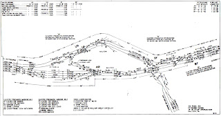
Anyway, based on his images I revised the track plan to include SF tower and the junction...
 |
| Revised Allegheny Eastern Track Plan March 28th, 2013 |
Actually building this scene presents other challenges, the most difficult being the flyover. The branch tracks will have to drop fast in order to realistically clear the flyover on the eastbound mains. Those mains themselves can be raised a bit. All my information indicates that there was a vertical separation between the two sets of mainline tracks. By lowering the branch while raising the eastbound main, I should be able to finagle enough room to park a train there, waiting for a clear signal that will never happen.
Regards
Frank Musick
Chief Cook and Bottle Washer
 |
| Allegheny Eastern Railroad |


No comments:
Post a Comment